
Partnerships across the federal government and academia’s operational and research communities are working to develop a next-generation airborne radar to enhance atmospheric observations for better predictions of high-impact weather like hurricanes, atmospheric rivers, tornadoes, derechoes, and blizzards. The National Science Foundation (NSF), the National Oceanic and Atmospheric Administration (NOAA), and the National Center for Atmospheric Research (NCAR) are working to research, develop, and implement new dual-pol radar devices that provide enhanced measurement capabilities allowing forecasters access to more accurate and timely information.
NOAA’s Weather Program Office (WPO), a program within the Office of Oceanic and Atmospheric Research (OAR), has been funding the initial research and development of Airborne Phased Array Radar (APAR) at NCAR since 2017. The Bipartisan Infrastructure Legislation of 2023 provided an additional $10 million of funding to NCAR through NOAA, with the NSF making a commitment of $91.8 million in June to continue work on this groundbreaking technology.
After the retirement of X-band Electra Doppler radar (ELDORA) in 2013, NOAA knew its Tail Doppler Radar (TDR) would need to be replaced when the NOAA Hurricane Hunter P-3s are updated to a new C-130J aircraft design in 2030. From 2017 to 2021, WPO awarded $8.5 million to the National Center for Atmospheric Research (NCAR) to support the initial design, development, and risk assessment of the APAR system.
APAR is replacing outdated fixed-direction radars, allowing simultaneous and agile atmospheric scanning. These radars will be installed on NOAA Hurricane Hunter Aircrafts and provide much needed information to scientists and forecasters alike. “As society struggles with an increase in devastating extreme weather events, it’s imperative that the Earth system science community has the tools it needs to provide the actionable information communities need to become more resilient,” said NCAR Director Everette Joseph. “APAR is one such tool. We’ve been working on this important technology for more than a decade, and I’m thrilled that we will be able to put it to use serving society.”
APAR will be the world’s first phased array C-band, dual-Doppler, dual-polarization radar with fast-scan agility to be carried on an aircraft. It will feature four removable Doppler C-band Electronically Scanned Arrays (AESAs) radars mounted on top, both sides, and the cargo ramp of the new C-130J hurricane aircraft, with signal processing, control, and display software housed in the interior of the aircraft. This configuration will provide real-time, high resolution, three-dimensional, and atmospheric observations. The Dual Horizontal/Vertical Polarization (Dual-Pol) technology will allow the atmosphere to be sampled at a higher spatial resolution and help observe the microphysical properties of clouds and hydrometeors by probing deeper into storms.
As it flies over land and oceans, APAR will get “remarkably close 3D views of what is going on deep inside clouds and severe storms.” This new technology takes our understanding of how rain, hail, and snow are formed, as well as severe convective systems and tropical storms to a new level that improves weather prediction and climate projections with models. These observations will provide critical data needed to improve operational forecasts and understanding of hurricanes, atmospheric rivers, severe storms intensity and structure, extreme precipitation, and severe convection.
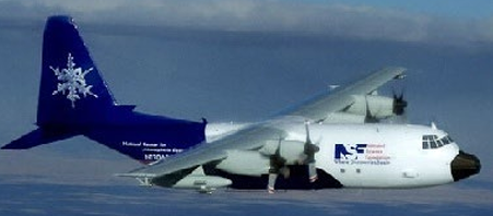
NOAA’s current Hurricane Hunter planes, Kermit, Miss Piggy, and Gonzo have been flying since the 1990s into hurricanes to collect vital data to preserve life and property and advance our understanding of the atmosphere. Rick Spinrad, Administrator of the National Oceanic and Atmospheric Administration, said that the new “Airborne Phased Array Radar will enable a transformative leap in our radar and data-collecting capabilities and lead to improved forecast guidance.” It can help predict sudden changes in tropical storm intensity and what type of precipitation is inside storm clouds whether it is raindrops, hail, sleet, or snow.
Scientists will have insight into the changing life cycle of severe storms and be able to monitor dramatic changes in intensity, eyewall formation and the spiral rainband structure. APAR will improve the prediction of severe weather events and allow communities to develop solutions to make them more resilient as part of a Weather-Ready Nation.
The project’s principal investigators (PIs) from NCAR will work to further develop the engineering design of the APAR system over the next 2 years. The breakthroughs being used to develop APAR will “push the boundaries of phased-array-radar technology” and advance the techniques for signal processing that are used to harvest and analyze the extensive volumes of data.
WPO is playing an integral role in leading the development of the transition plan by coordinating subject matter experts (SMEs) from NOAA Office of Marine & Aviation Operations (OMAO), NOAA Environmental Modeling Center (EMC), National Hurricane Center (NHC), NOAA Atlantic Oceanographic and Meteorological Laboratory (AOML), NOAA Technology Partnership Office (TPO), and NCAR. The progress supported by this funding has been closely coordinated through OAR, OMAO, and NOAA National Weather Service (NWS).


